About Our Rocky Mountain National Park Photo Tour Locations
Available Tours:
1 & 2 Day Custom Photography Workshops
Rocky Mountain National Park & Surrounding Area
Conducted Daily on Request
Photo Tour & Photography Workshop
RMNP Wildlife Safaris with Dawn Wilson
Rocky Mountain National Park
The Rocky Mountain National Park is a grand showcase of scenic mountain vistas in a variety of eco-zones that range from 8,000 feet to the top of Long’s Peak at 14,259 feet. Painter Albert Bierstadt began creating paintings that must have looked surreal to the people in the East in the second half of the 1800’s. Photographers soon followed and have long since made the grandeur of the Rocky Mountains one of their favorite subjects.
Great photo subjects include Trail Ridge Road, Hallet Peak, Nymph Lake, the alpine tundra, elk, especially during rutting season, Beaver Meadow and a host of lesser-known spots. The trick, of course is know when to be there… sunrise or sunset or mid-day?… what season, what time of day?… the best way to shoot the scene. That’s what we’re here for. We’ll get you to the right places at the right time with the right shooting advice to get you home with the images of a lifetime. 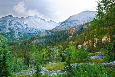
The majestic Rocky Mountains offer the best in alpine environment photography that includes mining ruins, ghost towns and just spectacular mountain scenery. Rocky Mountain National Park encompasses the nation's highest continuous road at over 12,000' ASL and the 72 peaks in the park provide endless photo opportunities. Trail Ridge Road typically opens on or before Memorial Day and spectacular Fall River Road opens by July 4th. Rocky Mountain National park has it all, from vast landscapes, wildflowers, falls and wildlife. Moose can sometimes be photographed on the west side of the Continental Divide. One workshop participant recently had the good fortune of photographing the park's only known wolverine. Opportunities to photograph elk, marmots, pika, etc are readily available if you know where to be and when to be there.
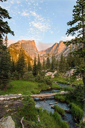
The road system of Rocky Mountain National Park offers photographers access to diverse ecosystems characterizing the higher regions of the central Rocky Mountains. The roads take visitors through lowland meadows and aspen groves, along swift-flowing rivers and up through subalpine forests to more than 12,000 feet in elevation.
No other national park roads offer the dramatic experience of a long drive across alpine tundra region, and few offer such a wide variety of experiences. The careful relationship of the park roads to the landscape results in a road system that generally harmonizes with the environment. Roadway alignments were chosen to highlight natural features, and scenic vistas and overlooks were provided to allow visitors to take in the magnificent terrain. The stone parapet walls and road-related structures, constructed in the National Park Service’s distinctive rustic style of architecture, relate well to their natural surroundings and help evoke a distinctive experience.
Colorado’s National Forests and Rocky Mountain National Park offer grand vistas with a variety of life zones and snow-capped mountain ranges towering above 14,000 feet above sea level.
Your personal invitation from Rocky Mountain National Park...
 "I am the park of superlatives and unexpected contradictions: highest continuous road in US, largest expanse of alpine tundra, vast number of undeveloped acres, most impressive display of testosterone-frenzied Elk in full rut, inspiring carpet of exquisitely small alpine wildflowers. I am so special that in 1976 I was named the 21st Biosphere Reserve.
Although I have 415 mostly undeveloped acres, I attract over 3 million visitors each year. Being only 2 hours from Denver and easily accessible, I suffer from incongruously over-crowded roadways milling crowds.
I epitomize the great “Rocky Mountain High”, a landscape of massive, timeless grandeur and desperate fragility. When I say high, I mean HIGH! Where else can you see more than 110 peaks above 10,000 feet? These are just the peaks with names; there are perhaps more yet to be named. Longs Peak is the tallest at 14,259 feet, but there are 72 over 12,000 feet."
Trail Ridge Road is the main thoroughfare through the park and the highest continuous motorway in the US. It began its life as a Ute Indian pathway across the Continental Divide as they followed their game in a seasonal vertical migration from high elevation summer meadows to low elevation winter grounds. Before the Utes, the paleo Indians drove herds of animals over steep cliffs called “jumps.” 35 game drive sites found west of Denver in a 15 mile stretch of mountains. Sites have been found on alpine tundra in RMNP. It’s amazing to think of thousands of years of hunters with spears (bows and arrows were acquired between 400 and 650 AD) driving big game over “buffalo jumps” to stock their larders for the cold, hard winters.
Trail Ridge can be an irritatingly slow slog amid the steady stream of family mini vans and campers of every description. It is common to see delighted tourists hop out of their cars to have snowball fights and take mid-summer photos of themselves against a backdrop of huge snowbanks that last almost all summer.
Do yourself a favor and enjoy the many turnoffs, read the interpretive signs, take a deep cleansing breath and savor the “top of the world” views, the thin alpine air, and the unique cross section across diverse mountain ecosystems.
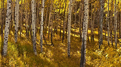
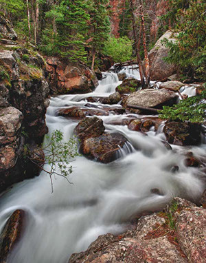
This singular road traverses representative examples of all major vegetation communities found in the central Rockies, with elevations from 7,640 feet to over 14,000. In relatively low areas, usually below 9,000 feet, Ponderosa pine and juniper cloak the sunny southern hillsides, and Douglas fir blankets the cooler northern slopes. Colorado state tree, the thirstier Colorado blue spruce, and Lodgepole pine cling to stream sides. The lovely riparian, stream-side areas are perfect for willow and cottonwood and the occasional grove of aspen.
The montane ecosystem is lower, warmer and more open. The greatest variety of wildlife makes use of this zone. Elk and mule deer browse the brushy under story, while the distinctive, black long-eared Abert squirrels dine on the ponderosa pine's seeds and twigs. The Chickarees, also known as pine squirrels or red squirrels, harvest the seeds of the Lodgepole pine. They will protest your passing through their domain with their distinctive high-pitched chirping.
As you gain elevation the subalpine zone between approximately 9,000 and 11,000 is higher and colder and wetter. Surprisingly luxurious forests of Englemann spruce and Subalpine fir blanket the hillsides. These water-loving trees do well because this area gets the most snowfall and the moisture-laden blanket stays longest beneath the shelter of the dense forest.
Just below the tree line, is a transition area where trees called krummholz, a German word meaning "crooked wood," are typical. Here trees, predominantly spruces and firs, grow very slowly and are stunted and deformed from the harsh, near-alpine conditions. Winds in this zone are so ferocious that branches will often grow only on the trees' downwind side, giving them gnarled, tortured shapes that are very photogenic, but are evidence of a difficult life in these marginal conditions.
The crowning glory of Trail Ridge Road is the expanse of alpine tundra, a fragile community of tiny gem-like plants specialized to eke out a living in extremely harsh conditions. Tundra is Russian for "land of no trees." About 100 square miles 1/3 of the park is above timberline which at this latitude is roughly 11,000 to 11,500 feet. This fragile and beautiful expanse is probably the most accessible and extensive example of alpine tundra found in the west. Much of it is visible from Trail Ridge Rd.
A variety of amazing adaptations allow these hardy, plant communities to thrive hugging the ground to avoid the worst of the persistent winds and extreme cold. Alpine tundra plants are long-lived perennials. The short growing season and harsh winds make life for annuals intolerable. Many species sport jackets of fine hairs on stems or leaves. These communities create microclimates that are a few degrees warmer and more sheltered, allowing them to survive the long, bitter winters to thrive once more in the very short 60 day growing season.
 Watch for Pika, in scree fields and talus slopes. These adorable little creatures do not hibernate, but stay active beneath the snows of the long, cold winters by harvesting and storing “hay” for winter consumption. Yellow-bellied marmots love to sun bathe on warm rocks. They live in colonies and whistle when alarmed. You might spot the iconic big-horn sheep effortlessly navigating the steepest, most unlikely precipices.
The fall elk rut is a spectacle of nature worthy of prime time TV. Drama ensues as the bulls round up and attempt to defend their harems from all challengers. The action includes sparring with huge antlers entwined, chasing intruders away and the bulls’ incongruously high-pitched squealing called bugling.
Before there was Trail Ridge Road there was Fall River Road, the original access to RMNP’s alpine tundra. Constructed in 1920 it preserves the feeling that it would best be negotiated in a Model T. It is not for the faint of heart, being narrow, mainly gravel with many switchbacks, precipitous drop-offs and few guard rails. The pace is slow, 15 MPH, and gives a close up and personal experience of Nature’s wonderland.
Colorado Plateau Photo Tours is licensed to operate in
Canyonlands National Park, Arches National Park, Rocky Mountain National Park, Grand Canyon National Park,
Grand Teton National Park, Yellowstone National Park, Dead Horse Point State Park (Utah), Everglades National Park,
and the Federal lands in the SE Utah, Cedar Mesa area.
BOB MAYNARD • COLORADO PLATEAU PHOTO TOURS • Tel: 303.547.0807
Copyright • Colorado Plateau Photo Tours, LLC & Bob Maynard Photography, All rights reserved, worldwide.